Medieval History


- Lecture On ?place Names And Saints? Cults: A Window On Medieval Scotland? To Be Given In Derry
In celebration of Colmcille Day, the Northern Ireland city of Derry is hosting a lecture by Gilbert Markus on ?Place Names and Saints? Cults: a window on medieval Scotland.? The lecture takes place today at the Tower Museum and is organised by Derry City...
- Journal Of Literary Onomastics 5 (2016)
Call for Submissions: Journal of Literary Onomastics 5 (2016)(a special issue on place and place-names in the early Insular world) The deeply rooted importance of landscape, place, and place-names is a shared characteristic throughout the...
- Rich Names, Poor Names: Social Status And Naming Patterns In The Middle Ages: Cfp
=================================================================== Rich Names, Poor Names: Social Status and Naming Patterns in the Middle Ages Call for Papers Leeds International Medieval Congress 11 -...
- Perceptions Of Place: English Place-name Study And Regional Variety
Perceptions of Place: English place-name study and regional variety An international conference to be held in association with the English Place-Name Society at the Institute for Name-Studies, University of Nottingham Wednesday 23 ¬¬? Sunday 27 June...
- Karlsborg: A Castle By The Sea
KARLSBORG ? A CASTLE BY THE SEA Just south of Hamburgsund in Bohuslän lies a place commonly known as ?Slottet?. This is in an area nowadays mostly inhabited by summer guests, due to the exclusive attraction of Bohuslän's extensive archipelagos....
Medieval History
MEDIEVAL BOHUSLÄN: On the history of place names
ON THE HISTORY OF PLACE NAMES
My previous posts (part 1 and 2) have been concerned with a castle ruin called Karlsborg, to the south of Hamburgsund. I have tried to put this rather unexplored ruin into a historical and economic context. More questions have been raised than answered by my investigations, and it is necessary to further explore this castle using both microscopic and macroscopic forms of research. Today, we will be investigating the historic place names of Bohuslän in general, in order to see what this information might tell us about the context of Karlsborg.
The use of place names in historical research is, according to me, somewhat controversial, at least in more deterministic forms of toponomy. We need to exercise caution when using this information as a base for our interpretations, as it is sometimes difficult to know exactly when a place was named, and why. However, toponomy in Sweden is based on profound research, both linguistic and historical, and it is an intriguing material to use.
Beneath, I have selected some general elements in place names, from different periods, and tried to analyse their geographical patterns through the use of GIS. As I am quite the novice in the use of place names in historical research, I ask you not to take this analysis too seriously. The material used is heavily generalized, and a closer investigation would be needed in order to use this in more serious research. However, I think that even this shallow analysis have provided me with a nice picture of the historical development of Bohuslän?s settlement patterns.
Prehistoric Place Names

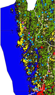
A map showing prehistoric place names in Bohuslän. The white line marks the border of Bohuslän to neighboring counties.
Blue: -by
Blue: -by
Purple: -hem
Light green: -landa
According to traditional toponomy, there are certain place names that can be traced back to a pre-christian period. In Bohuslän, these are names ending with either ?-by?, ?-hem? or ?-landa?, e.g. ?Svenneby?, ?Solhem? or ?Kavlanda?. The map shown above is made by selecting present day communities with these elements present in their names. It is clear that ?-by? is the most common prehistoric element in Bohuslän?s place names. We should also note, as seen in the map above, that inland Bohuslän is quite devoid of communities with prehistoric place names. This might illustrate that settlements, at least in the late iron age, were shaped by the fact that most arable soils in this region are located close to the coast. We can also assume that these rural communities, though mainly agricultural, also considered fish an important part of their sustenance.
Medieval Place Names

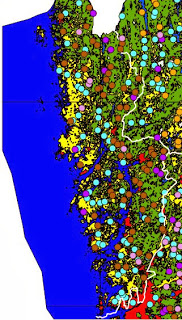
Map showing settlement development in the middle ages. The white line marks the border of Bohuslän to neighboring counties.
Blue: Prehistoric names
Purple: -hult
Orange: -rud
Brown: -röd
Pink: -torp
Place names from the medieval period in Bohuslän usually contain the elements ?-röd?, ?-rud?, ?-torp? and ?-hult?. Most of the medieval names in Bohuslän contain the element ?-röd?, referring to cleared ground, and often cultivation. The map above shows a potential development from prehistoric to medieval times, were most of the densely forested area have been colonized. Usually, this phenomenon have been connected to the population growth of the High Middle Ages which, along with technological development, allowed previously quite uninhabited areas to be settled. The initial expansion was halted in the middle of the 14thcentury, with the outbreak of the Black Death and the following economical decline, also in combination with the environmental change to what have been called ?The Little Ice Age?.
The redoubled amount of settlements seen in the map should not be interpreted as a redoubling of the population during the High Middle Ages. Most of these new settlements were small, lacking the more extensive farmlands found in older communities. Perhaps, we can connect this new settlement pattern to an increased use of the forest itself, but this requires further investigation. Timber was important trade goods in medieval Scandinavia, but whether the settlement expansion in Bohuslän is connected to this, we cannot at the moment tell.
Karlsborg and Place Names

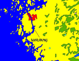
Place names around Karlsborg
Blue: Prehistoric names
Brown: -röd
Pink: -torp
This investigation has not clearly shown any connection to the region around Karlsborg. We cannot observe any community name in the immediate area containing the historic elements under study. The closest settlements are Svenneby, Smedseröd, Skogby and Allestorp, all presumably existing simultaneously with the castle and within a 8km radius.. However, they do not indicate any certain importance connected to the location of Karlsborg. This might be explained by the fact that we have excluded many historic places in our investigation (important places such as Dynge, Apelsäter, Hallinden and Vettland are not included), where we have sought a general pattern rather than interesting particularities. More local place names, among them the names of rivers and natural features, should be taken into account when conducting a more localized analysis.
If we ignore the above criticism, however vital it may seem, we can assume that the region was not particularly important or special in the High Middle Ages, and that the importance can be connected to the later middle ages. Many of the place names in the investigation above defines settlements founded in the initial expansion of the earlier middle ages, and the pattern may have changed during the later middle ages. If the area around Karlsborg had been previously unimportant, it would explain why the site was not extensively fortified until the middle of the 15th century. This, at least in a very generalized way, supports the idea of seasonal fishing, caused by a herring period, as a foundation for the importance of Hamburgsund and Karlsborg. While written history does not support this theory, it is not unlikely. Maybe be the lack of documentation of this period can be traced to a high degree of international activity in the area. More on this in coming posts!
That was all for now! As usual, you are more than welcome to share your thoughts and ideas on the topic discussed. If you found this post interesting, feel free to leave a comment!
- Lecture On ?place Names And Saints? Cults: A Window On Medieval Scotland? To Be Given In Derry
In celebration of Colmcille Day, the Northern Ireland city of Derry is hosting a lecture by Gilbert Markus on ?Place Names and Saints? Cults: a window on medieval Scotland.? The lecture takes place today at the Tower Museum and is organised by Derry City...
- Journal Of Literary Onomastics 5 (2016)
Call for Submissions: Journal of Literary Onomastics 5 (2016)(a special issue on place and place-names in the early Insular world) The deeply rooted importance of landscape, place, and place-names is a shared characteristic throughout the...
- Rich Names, Poor Names: Social Status And Naming Patterns In The Middle Ages: Cfp
=================================================================== Rich Names, Poor Names: Social Status and Naming Patterns in the Middle Ages Call for Papers Leeds International Medieval Congress 11 -...
- Perceptions Of Place: English Place-name Study And Regional Variety
Perceptions of Place: English place-name study and regional variety An international conference to be held in association with the English Place-Name Society at the Institute for Name-Studies, University of Nottingham Wednesday 23 ¬¬? Sunday 27 June...
- Karlsborg: A Castle By The Sea
KARLSBORG ? A CASTLE BY THE SEA Just south of Hamburgsund in Bohuslän lies a place commonly known as ?Slottet?. This is in an area nowadays mostly inhabited by summer guests, due to the exclusive attraction of Bohuslän's extensive archipelagos....
