Medieval History


Homestead
Homestead
Homestead
- 34th Annual Harvard Celtic Colloquium
10, 11 and 12 October 2014 The Thompson Room (Room 110) Barker Center, 12 Quincy Street ~ Call For Papers The organizers of the 34th Annual Harvard Celtic Colloquium acknowledge with thanks the support of The Provostial Funds Committee for the Arts and...
- Upcoming Assc Event
The Anglo Saxon Studies Colloquiumannouncesa lecture and seminar *Joshua Davies* *(KIng's College, The University of London)* ??Visions...
- Author Interviews Coming To Ancient & Medieval Mayhem Blog In June
ROBYN YOUNGInterview with Author, Robyn Young. In early June to kick off the Ancient & Medieval Historical Fiction Group's Medieval Group Read of Insurrection. ...
- Transitional
Martin church near Horncastle in Lincolnshire, has a fabulous chancel arch. This narrow arch is a text book example of the Transitional style, the moment when Norman architecture gradually gave way to Early English Gothic. ...
- How's This For A Bit Of Atmosphere
A fifteenth century Seven Sacrament font in Ham stone, sandstone recesses with thirteenth and fourteenth century effigies of the Ralegh family, a late medieval waggon roof, a patchwork of old flooring and a late seventeenth century tablet...
Medieval History
A VISIT TO A 17th CENTURY VILLAGE part.2: Homesteads and Outfields
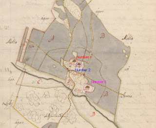
Today we are going to investigate the village of Stjärnholm
The village of Stjärnholm, with the homesteads marked
Notarum explicatio
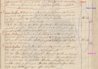
The first thing usually described on each homestead is the name of the farmer. These names are very common even today, and almost all of them have surnames ending with ?-son?. In this particular village we have two farmers (in homestead 1 and 3) surnamed ?Larsson?. We cannot be sure that these two are related to each other as this is a common surname, but as they inhabit the same village it is quite likely.
After the names comes the land owning nature of the homestead, such as ?krono?, ?skattekrono?, ?frälse? etc. If the land is ?frälse? (owned by a noble) sometimes the name of the nobleman/woman or the estate is noted.
The third thing described is the value of the farmers? land in the unit ?öresland?. Öresland is a unit that does not necessarily describe the amount of land; it can also be a description of the revenues. The exact meaning of this unit seems somewhat uncertain depending on what area you are investigating. In Uppland, there seems to be a quite clear correlation between öresland and tunnland. In the YGK-project we are converting all land values into the same unit, called penningland (1 öresland is the same as 24 penningland) which is more common in this period. This is done in order to make the statistics from various areas comparable with each other.
After this, the annual revenues of the homestead are described. Each homestead usually use the two field system and therefore the revenues are described for each year of farming.
Under the revenues, you can sometimes find information on areas used by the farmer which lie outside the village (in Swedish ?utjordar?), often in a neighbouring area. Sometimes the revenues for these patches of land can be found in the homesteads description, but most of times this is described in another map, if such exists. More on this below.
Another thing to note here is something found above the description of the homesteads. We can usually find information here about the outfields (though it is not really fields) of the village. The outfields or the ?outlands? (perhaps a better term) of a village are usually used for grazing, gathering of firewood, fishing and some hunting. Outlands are usually not described in detail, but the quality is defined by terms such as ?good fishing? or ?almost no firewood at all?. In this case we can read that the outland of Stjärnholm consists of bare ground which provides poor grazing.
Now we will investigate the homesteads:
This farm also owns three patches of land in other areas. Specifically these areas are: ?Wreeta?, ?Fänsgiärde? and ?Fittja parish?. If these areas are mapped or not we cannot at the moment know. All that can be said is that they do not exist in the same volume of maps (named A16).
In short:
Homestead Owning Fields(tunnland) Meadows(lass) Value(pen)
1 skattekrono 21.945 15.448 336
2 frälse 23.121 16.275 354
3 frälse 23.121 16.275 354
That was all for now. Hope you have enjoyed your visit to Stjärnholm village!
NOTE:
All maps taken from http://www.lantmateriet.se/
NOTE:
All maps taken from http://www.lantmateriet.se/
- 34th Annual Harvard Celtic Colloquium
10, 11 and 12 October 2014 The Thompson Room (Room 110) Barker Center, 12 Quincy Street ~ Call For Papers The organizers of the 34th Annual Harvard Celtic Colloquium acknowledge with thanks the support of The Provostial Funds Committee for the Arts and...
- Upcoming Assc Event
The Anglo Saxon Studies Colloquiumannouncesa lecture and seminar *Joshua Davies* *(KIng's College, The University of London)* ??Visions...
- Author Interviews Coming To Ancient & Medieval Mayhem Blog In June
ROBYN YOUNGInterview with Author, Robyn Young. In early June to kick off the Ancient & Medieval Historical Fiction Group's Medieval Group Read of Insurrection. ...
- Transitional
Martin church near Horncastle in Lincolnshire, has a fabulous chancel arch. This narrow arch is a text book example of the Transitional style, the moment when Norman architecture gradually gave way to Early English Gothic. ...
- How's This For A Bit Of Atmosphere
A fifteenth century Seven Sacrament font in Ham stone, sandstone recesses with thirteenth and fourteenth century effigies of the Ralegh family, a late medieval waggon roof, a patchwork of old flooring and a late seventeenth century tablet...
