Medieval History
Among the current developments in archaeology, history and geography the Digital evolution is by far the most significant one. The digitalization of historical information is a recurrent theme in projects at archives, museums and universities. Geographically bound data makes it possible to conduct larger studies at a previously quite inaccessible scale, and the importance of a geographical focus, not the least in the building of easily searchable databases, is clearly something that have recently been realized by several institutions. The use and the ongoing development of GIS software have contributed much to this movement. Alongside with the digital evolution there have also been a lot of discussion about the public accessibility of digital information. That is, the ?free or not free? part of this data. Among the people working with open source software this is something almost religious, where all data should be downloadable for free. In other cases, especially where the data can be used for commercial purposes, the data is often (at least partly) available to view, but only downloadable for ?premium? members (which means that you have to pay).
That was all for now. Please, feel free to send an email to [email protected] if you have further questions!
- People Of Medieval Scotland Online Database Officially Launched
A new interactive online database, which will make thousands of the oldest documents in Scotland?s history available to the public, has been officially launched today during an event at the University of Glasgow. The People of Medieval Scotland (PoMS)...
- Review Of Digitized Medieval Manuscripts Maps
Over the past few days, medievalists have been abuzz about a new resource for manuscript study in the digital age: the folks at Sexy Codicology (a team made up of Giulio Menna and Marjolein de Vos) launched the Digitized Medieval Manuscripts...
- Digital Humanities Workshops: Metadata, Markup And Emerging Tools For Scholarly Analysis And Presentation
Digital Humanities Workshops: Metadata, Markup and Emerging Tools for Scholarly Analysis and Presentation The DHO in conjunction with the University of Ulster is proud to present two one-day digital humanities workshop events: Seeing Data Differently...
- A 17th Century Landscape Through Historical Maps: Arcscene Visualisation
Hello everyone!The last couple of days I have started a small (yet unfinanced) research project aimed at applying the principles of LCA (Landscape Character Assessment) and HLC (Historic Landscape Character) in a 17th century context. While LCA...
- On Historical Maps And Rectification
The rectification of historical maps is a commonly used tool for understanding landscapes and archaeological sites. It is often used by contract archaeology to determine the location of potentially interesting features. By landscape archaeologists rectification...
Medieval History
Historical Geographical Databases: An Introduction to GEORG
Among the current developments in archaeology, history and geography the Digital evolution is by far the most significant one. The digitalization of historical information is a recurrent theme in projects at archives, museums and universities. Geographically bound data makes it possible to conduct larger studies at a previously quite inaccessible scale, and the importance of a geographical focus, not the least in the building of easily searchable databases, is clearly something that have recently been realized by several institutions. The use and the ongoing development of GIS software have contributed much to this movement. Alongside with the digital evolution there have also been a lot of discussion about the public accessibility of digital information. That is, the ?free or not free? part of this data. Among the people working with open source software this is something almost religious, where all data should be downloadable for free. In other cases, especially where the data can be used for commercial purposes, the data is often (at least partly) available to view, but only downloadable for ?premium? members (which means that you have to pay).
Today, I will introduce you to a Swedish database named GEORG, the elder sister of the database KARL that I have contributed to this spring. See my earlier posts for more on KARL and the project YGK.
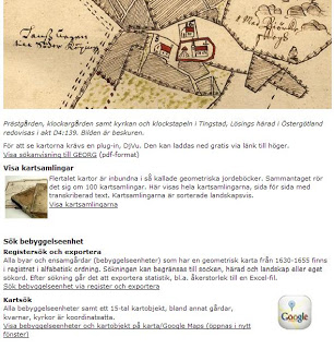
GEORG is a complex database built mainly for researchers. Here we see some of its basic functions such as "Show map collections", "Search register and export" and "Search by map"?
GEORG is the result of a project named ?Nationalutgåva av de äldre geometriska kartorna? (National edition of the elder geometrical maps). This project had its base at the National Archives in Stockholm and was led by Clas Tollin, docent at the department of agrarian history at SLU in Uppsala. The project lasted between 2001-2010 and the goal was to make the information in the geometrical maps from 1630-1655 easily accessible to researchers and other interested individuals. This meant that the maps, previously scanned in quite poor quality, had to be rescanned in high quality and all the information had to be geographically registered with the use of GIS. In addition, all the written text describing the maps were transcribed and digitalized. The maps themselves follows almost the exact same pattern as the Younger geometrical maps, which I have described in detail in earlier posts. The result is a database where all the data is accessible and downloadable. At the moment, the site is only available in Swedish, though an English translation is planned.
This database was among the first of its kind, and a landmark in the evolution of geographic historical databases. At the present there are many projects going on using many of the same principles. For readers fluent in German there is a highly ambitious project going on in Pomerania, which in the 17th century was a part of the Swedish Empire. For readers more comfortable with English than these other languages I can recommend you to look at the database for the Down Survey of Ireland, which can be compared to GEORG. This database is also concerned with 17th century maps, though the material is quite different. Links to these projects can be found below.
That was all for now. Please, feel free to send an email to [email protected] if you have further questions!
GEORG:
http://www.riksarkivet.se/default.aspx?id=21561&refid=22519
Svea Pommern:
http://www.svea-pommern.de/
Down Survey of Ireland:
http://downsurvey.tcd.ie/
- People Of Medieval Scotland Online Database Officially Launched
A new interactive online database, which will make thousands of the oldest documents in Scotland?s history available to the public, has been officially launched today during an event at the University of Glasgow. The People of Medieval Scotland (PoMS)...
- Review Of Digitized Medieval Manuscripts Maps
Over the past few days, medievalists have been abuzz about a new resource for manuscript study in the digital age: the folks at Sexy Codicology (a team made up of Giulio Menna and Marjolein de Vos) launched the Digitized Medieval Manuscripts...
- Digital Humanities Workshops: Metadata, Markup And Emerging Tools For Scholarly Analysis And Presentation
Digital Humanities Workshops: Metadata, Markup and Emerging Tools for Scholarly Analysis and Presentation The DHO in conjunction with the University of Ulster is proud to present two one-day digital humanities workshop events: Seeing Data Differently...
- A 17th Century Landscape Through Historical Maps: Arcscene Visualisation
Hello everyone!The last couple of days I have started a small (yet unfinanced) research project aimed at applying the principles of LCA (Landscape Character Assessment) and HLC (Historic Landscape Character) in a 17th century context. While LCA...
- On Historical Maps And Rectification
The rectification of historical maps is a commonly used tool for understanding landscapes and archaeological sites. It is often used by contract archaeology to determine the location of potentially interesting features. By landscape archaeologists rectification...