Medieval History
Here are some results from a rectification I just did, using the methodology described in the last post. The map in the last post did not give a good result, as it was heavily distorted by the surveyor whom I now actively distrust. ;-)
But the map in the last post illustrates some of the key problems in rectificating these old geometrical maps. As a result of their instruments and methods, the surveyors only had limited possibilities to cover a whole area, escpecially from one position. The surveyor had to change position (from where he was measuring and triangulating) several times during his work. Features of real importance were usually measured from a close distance and this is why the maps are more accurate inside the actual boundaries (in swediish called "hängnad") of the farming lands. Outside these boundaries the maps are sometimes quite distorted or innaccurate, so caution must be observed. Furthermore, some surveyors were apparently MUCH more accurate than others. A man named Jacob Braun, whose maps I am currently quite engaged with, appears to have made a good effort in making accurate measurements over long distances.
What does this mean for we who are rectifying? This means that even if we identify key common features in the map, it might sometimes be so heavily distorted (especially in the edges) that a good rectification is almost impossible. The people I'm working with are somewhat more up to date on this matter, so I'll be giving you more information on how to confront this problem in the near future.
Here is another case study, with one of Jacob Braun's maps. :) The result proved quite good, considering that is almost only just an overlay and the map is really old.
- Call For Papers ? The Language Of Maps: Communicating Through Cartography During The Middle Ages And Renaissance
A colloquium and exhibition at the Bodleian Library, University of Oxford Thursday June 23 to Saturday June 25 2011 Historic maps have broad appeal in contemporary cultures around the world. One reason for this ? it might be thought ? is because the ?language...
- A 17th Century Landscape Through Historical Maps: Arcscene Visualisation
Hello everyone!The last couple of days I have started a small (yet unfinanced) research project aimed at applying the principles of LCA (Landscape Character Assessment) and HLC (Historic Landscape Character) in a 17th century context. While LCA...
- A Visit To A 17th Century Village Part.2: Homesteads And Outfields
Today we are going to investigate the village of Stjärnholm once again, this time focusing on the homesteads themselves and the information we can find about them in Notarum explication. For more about this village, please read my earlier post! The...
- A Visit To A 17th Century Village Part.1: Landowning And Measurement Units
Though rectification and everything might be really interesting and useful, I thought today that I might talk a bit about the village economy of the 17th century. This is not only an interesting subject in itself, but also it gives you a...
- Work Placement At The National Archives
WORK PLACEMENT AT THE NATIONAL ARCHIVES This week I started my work placement at the national archives in Stockholm, Sweden. I am currently working as a trainee in a project called ?Yngre geometriska kartor? (Younger geometrical maps). We...
Medieval History
Rectification results!
Here are some results from a rectification I just did, using the methodology described in the last post. The map in the last post did not give a good result, as it was heavily distorted by the surveyor whom I now actively distrust. ;-)
But the map in the last post illustrates some of the key problems in rectificating these old geometrical maps. As a result of their instruments and methods, the surveyors only had limited possibilities to cover a whole area, escpecially from one position. The surveyor had to change position (from where he was measuring and triangulating) several times during his work. Features of real importance were usually measured from a close distance and this is why the maps are more accurate inside the actual boundaries (in swediish called "hängnad") of the farming lands. Outside these boundaries the maps are sometimes quite distorted or innaccurate, so caution must be observed. Furthermore, some surveyors were apparently MUCH more accurate than others. A man named Jacob Braun, whose maps I am currently quite engaged with, appears to have made a good effort in making accurate measurements over long distances.
What does this mean for we who are rectifying? This means that even if we identify key common features in the map, it might sometimes be so heavily distorted (especially in the edges) that a good rectification is almost impossible. The people I'm working with are somewhat more up to date on this matter, so I'll be giving you more information on how to confront this problem in the near future.
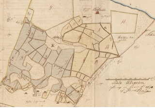
Here is another case study, with one of Jacob Braun's maps. :) The result proved quite good, considering that is almost only just an overlay and the map is really old.
A map of Hässle manor in Fittja parish, Uppland. Done by Jacob Braun in 1690.
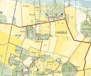
A modern day topographical map of the same area. The features in the map have all been added manually by measuring and triangulating in the old map. Only three georeference points were added, marked by the smaller red dots.
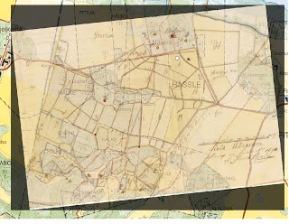
The rectified result, sorry for the bad quality. The transformation type I used is called Helmert, and basically only scales and rotates your picture. You can see almost all the marked features smoothly aligning with the historical map, with just a slight distortion. Most of the topography fits surprisingly well, as well.
That was all for now, stay tuned for more on this exciting subject!
NOTE:
All maps taken from http://www.lantmateriet.se/?
All maps taken from http://www.lantmateriet.se/?
- Call For Papers ? The Language Of Maps: Communicating Through Cartography During The Middle Ages And Renaissance
A colloquium and exhibition at the Bodleian Library, University of Oxford Thursday June 23 to Saturday June 25 2011 Historic maps have broad appeal in contemporary cultures around the world. One reason for this ? it might be thought ? is because the ?language...
- A 17th Century Landscape Through Historical Maps: Arcscene Visualisation
Hello everyone!The last couple of days I have started a small (yet unfinanced) research project aimed at applying the principles of LCA (Landscape Character Assessment) and HLC (Historic Landscape Character) in a 17th century context. While LCA...
- A Visit To A 17th Century Village Part.2: Homesteads And Outfields
Today we are going to investigate the village of Stjärnholm once again, this time focusing on the homesteads themselves and the information we can find about them in Notarum explication. For more about this village, please read my earlier post! The...
- A Visit To A 17th Century Village Part.1: Landowning And Measurement Units
Though rectification and everything might be really interesting and useful, I thought today that I might talk a bit about the village economy of the 17th century. This is not only an interesting subject in itself, but also it gives you a...
- Work Placement At The National Archives
WORK PLACEMENT AT THE NATIONAL ARCHIVES This week I started my work placement at the national archives in Stockholm, Sweden. I am currently working as a trainee in a project called ?Yngre geometriska kartor? (Younger geometrical maps). We...