Medieval History
WORK PLACEMENT AT THE NATIONAL ARCHIVES
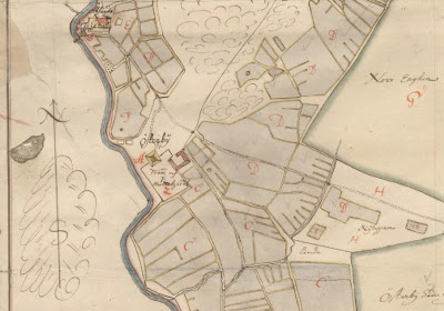
A map of Österby manor in Uppland from 1688 by a quite good cartographer named Petter Arosander, which I had the oppurtunity to register this week. The manor itself seems to have been replaced by a more modern one in later centuries though the foundations must still remain. The location of the church ("Ålands kyrka") in the northwest corner of the map remains intact. This was founded in the 15th century. The church village represented by the lonely house (the rest of the older village is located just west of the river) close to the bridge have even older origins and the name Åland can be traced to the 13th century.
- Warwickshire Manorial Records Going Online
Fines for playing tennis, selling shoes before o?clock in the afternoon, or being an ale house haunter, are just some of the penalties in force in Warwickshire 600 years ago. Documents detailing such historical gems can be found in the Warwickshire Manorial...
- Call For Papers ? The Language Of Maps: Communicating Through Cartography During The Middle Ages And Renaissance
A colloquium and exhibition at the Bodleian Library, University of Oxford Thursday June 23 to Saturday June 25 2011 Historic maps have broad appeal in contemporary cultures around the world. One reason for this ? it might be thought ? is because the ?language...
- A 17th Century Landscape Through Historical Maps: Arcscene Visualisation
Hello everyone!The last couple of days I have started a small (yet unfinanced) research project aimed at applying the principles of LCA (Landscape Character Assessment) and HLC (Historic Landscape Character) in a 17th century context. While LCA...
- Rectification Results!
Here are some results from a rectification I just did, using the methodology described in the last post. The map in the last post did not give a good result, as it was heavily distorted by the surveyor whom I now actively distrust. ;-) But the map in...
- On Historical Maps And Rectification
The rectification of historical maps is a commonly used tool for understanding landscapes and archaeological sites. It is often used by contract archaeology to determine the location of potentially interesting features. By landscape archaeologists rectification...
Medieval History
Work placement at the national archives
WORK PLACEMENT AT THE NATIONAL ARCHIVES
This week I started my work placement at the national archives in Stockholm, Sweden. I am currently working as a trainee in a project called ?Yngre geometriska kartor? (Younger geometrical maps). We are working with the digitalization of Swedish maps dating from the 17th century, putting coordinates on features found in the maps (like houses, mills, barns, bridges etcetc.) and making statistics of the mainly economical information found in the map descriptions. All the maps and the connected information are made publicly available through an online database called GEORG. For anyone interested in the historical geography of Sweden this provides a wealth of information previously rather unavailable. The landscape found in this maps have much older origins than the 17th century and conclusions about for an example medieval landscapes can be drawn from them. This is extremely exciting and I will keep you updated on the progress of our work this spring.
Here?s a link to the now finished project about the ?Older geometrical maps? which maps dates to the start of the 17th century. The material is already available for the keen researcher to use. Basic knowledge in Swedish is required, however.
http://www.riksarkivet.se/default.aspx?id=21561&refid=22519
- Warwickshire Manorial Records Going Online
Fines for playing tennis, selling shoes before o?clock in the afternoon, or being an ale house haunter, are just some of the penalties in force in Warwickshire 600 years ago. Documents detailing such historical gems can be found in the Warwickshire Manorial...
- Call For Papers ? The Language Of Maps: Communicating Through Cartography During The Middle Ages And Renaissance
A colloquium and exhibition at the Bodleian Library, University of Oxford Thursday June 23 to Saturday June 25 2011 Historic maps have broad appeal in contemporary cultures around the world. One reason for this ? it might be thought ? is because the ?language...
- A 17th Century Landscape Through Historical Maps: Arcscene Visualisation
Hello everyone!The last couple of days I have started a small (yet unfinanced) research project aimed at applying the principles of LCA (Landscape Character Assessment) and HLC (Historic Landscape Character) in a 17th century context. While LCA...
- Rectification Results!
Here are some results from a rectification I just did, using the methodology described in the last post. The map in the last post did not give a good result, as it was heavily distorted by the surveyor whom I now actively distrust. ;-) But the map in...
- On Historical Maps And Rectification
The rectification of historical maps is a commonly used tool for understanding landscapes and archaeological sites. It is often used by contract archaeology to determine the location of potentially interesting features. By landscape archaeologists rectification...